
The Oregon Department of Forestry is raising fire danger from moderate to high Monday in NW-02 and NW-03, the eastern and central portions of the Tillamook Forest and surrounding areas, including regions just outside of Forest Grove.
At 12:01 a.m. Monday, July 14, fire danger will be set to high, or yellow in two of three zones of the Northwest Oregon Forest Protective Association (NWOFPA).
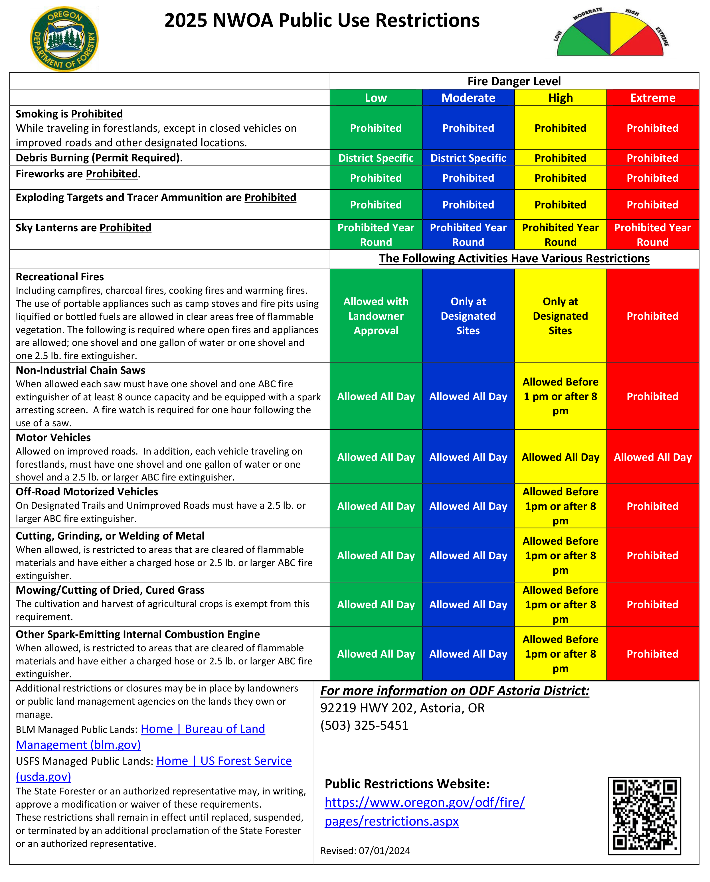
NW-01, which hugs the Oregon coast, will remain at moderate.
At the same time, IFPL levels in NW-02 and NW-03 will go up to level 2, ODF Astoria District Forester Dan Goody said in an email.
For the general public, high fire danger means a number of normally permitted forest activities must be limited to cooler times of the day.
All debris burning is prohibited during high fire danger.
-Non-industrial chainsaw use is prohibited between the hours of 1 p.m. and 8 p.m.
-Off-roading is prohibited between the hours of 1 p.m. and 8 p.m.
-Cutting, grinding, or welding metal is prohibited between the hours of 1 p.m. and 8 p.m.
-Mowing and cutting of dried, cured grass is prohibited between the hours of 1 p.m. and 8 p.m. (does not apply to agricultural crops)
-Use of other spark-emitting internal combustion engines is prohibited between the hours of 1 p.m. and 8 p.m.
See the full regulations below.
Not sure if you live in lands protected by the Oregon Department of Forestry? View the map below and click on your location to find out, or visit the map online for the full experience.
Fire season began June 23 in the region, and was placed at moderate on July 3.
"The statewide picture is starting to come into focus with numerous fires in Southwest Oregon and Klamath and lightning hitting eastern Oregon as I type," Goody said in the July 9 email.
The NWOFPA region includes much of the regions of Gales Creek, Buxton, Timber, Manning, and the Tillamook State Forest, among other areas. It stretches north to the Columbia River, west to the Pacific Ocean, south to Sheridan, and east to parts of Gales Creek, the Killin Wetlands outside of Banks and to Scappoose.
The public and industrial users of local forests can stay informed of current fire restrictions by visiting the agency’s Fire Restrictions & Closures website or calling their local ODF or protective association office, in this case, Forest Grove ODF offices for most of our readers at 503-357-2191.
As of July 1, all lands protected by the Oregon Department of Forestry had entered fire season.
Sign up for text alerts
Sign up for text alerts for real time fire season information in the Forest Grove, Tillamook, and Astoria ODF districts by texting “NWOA” to 877-274-4067.


